The Surveyor's Mantra: Follow in the Footsteps of the Original Surveyor
|
What is a surveyor? He is never very happy. He is always hunched over because he is always looking down at the ground. He carries a little book that he looks at and is always writing down numbers then cussing because the numbers in his book never match the numbers he writes down. He has one little eye and one Great BIG EYE. He stands out there and freezes in the rain and snow, he tromps through the mud, he fights off snakes, mosquitoes, chiggers, and ticks. Every now and then he finds something that makes him extremely happy and he does a little dance, then he starts measuring again in another direction. I don't know why anybody would want to be a surveyor.
Accurate Fast Cheap
Three things usually do not go together. You may get one, maybe two but don't expect to get all three. What is the Bottom Line? Remember if it goes to court the only thing anyone is going to worry about is accurate.
|

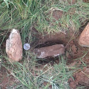
Northwest Corner Section 119, Block 2,
H. and G. N. RR Survey
Crosby County. Set by W.D. Twichell in 1907
|
Surveying Services
- Boundary Surveys
- ALTA Surveys
- Topographic Surveys
|
- Land Planning
- Subdivisions
- Route Surveys
|
- Data Collection
- Field to Finish
- Construction Staking
|
Stafford V. King
Unless it is shown otherwise, it is presumed the Surveyor actually made the Survey on the Ground.
As has been intimated, it is the purpose of the government and the locator to select a particular tract of land and designate it from the mass of the public domain. And hence the directions are given by law to run around the land--in fact, point out and define upon it such natural objects, or plain artificial marks, with courses and distances, by which the land can at all times be easily found and identified. Natural objects are mountains, lakes, rivers, creeks, rocks, and the like. Artificial objects are marked lines, trees, stakes, etc. A description [**19] of these objects and marks of identity should be faithfully transferred into the field notes, and thence into the patent, to serve the purpose aforesaid; and in all future controversies in respect to the locus or boundaries of the tract, recourse must be had to these calls, and when they are all found and established in conformity with those set forth in the patent, the conclusion is almost irresistible that the tract of land covered by the patent is identified, and there can be little or no room for controversy about the boundaries of the land; but when all the calls of the patent cannot be found or is found to be inconsistent with others, in whole or part, and leading to a different result or confusion, then it becomes important to look to the rules of law that must govern the action of the court and jury, in respect to the character and weight of the evidence to be considered by them in fixing upon and establishing the true boundaries of the survey.
DIGNITY OF CALLS:
Natural Monuments: Creeks, Rivers, Mountains, Bluffs
Artificial Monuments: Stakes, Mounds, Marked Trees
Course and Distance
Area
Contact us for accurate land surveys and comprehensive data collection.
SHARE THIS PAGE:

